Mappy Monday – My top 7 websites for medieval, early-modern & modern maps of London & Great Britain
London
1) Map of early modern London (1560-1640)
Fully zoomable (using an experimental google-style layered map) and searchable: Map of Early Modern London.
2) Tallis’s London Street views (1838-1840)
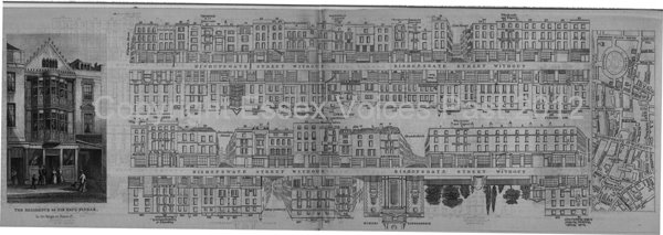
The nineteenth century’s equivalent of a modern-day street directory. This website doesn’t contain zoomable images but because Tallis’s maps are incredible resources for genealogists and local historians, I’ve included it: Tallis’s Street Views of London (and this link shows some of Tallis’s drawings for Bishopsgate). The Street View of Bishopsgate (below) is in my own personal collection. To my great delight, it contains the drawing of my ancestors’ factory (Robert and William Parnall) at 100 Bishopsgate.
 Tallis’s Street View of Bishopsgate Without.
3) Richard Horwood’s Map of London (1792-1799)
Plan of the Cities of London and Westminster,the Borough of Southwark, and Parts Adjoining (includes ‘every House’): Horwood’s Map of London Update June 2012: sadly this is now a broken link as the website no longer exists. If anyone finds another online map of Horwood’s London, please can you email me.
4) Locating London’s Past (using John Rocques’ 1746 map)
The map uses a GIS interface to enable researchers to plot and chart data relating to London in the 17th and 18th century: Locating London’s Past.
5) William Newton’s London and Westminster in the time of Henry VIII (pre 1530)
This map was made in 1855 and was compiled from documents and sources by Newton. The map is pre-Reformation and the 1530’s dissolution of the monasteries: London and Westminster in Henry VIII’s time. Update June 2012: sadly this is now a broken link as the website no longer exists. If anyone finds another online map of William Newton’s London, please can you email me.
Great Britain
6) The Gough Map of Great Britain (medieval c1360)
Fully zoomable and searchable map of medieval England, Scotland and Wales. Searchable by using either the modern-day names or the medieval names of towns: Gough’s Map
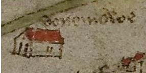
 Great Dunmow (Donemowe)
according to Gough’s Map of Great Britain.
7) John Speed’s Theatre of the Empire of Great Britain & counties (1611-12)
John Speed’s Map of Great Britain and Ireland. The site is Cambridge University’s online zoomable website containing all John Speed proof maps including one of Great Britain and Ireland , and also images every 1600s county of England, Wales, Scotland, Channel Islands, Isle of Man, and Ireland: John Speed’s proof maps.
There are plenty more websites out there which use modern-day technology on old maps. If you know of any others, please let me know.
*-*-*-*-*-*-*-*-*-*-*-*-*-*-*-*-*
This blog
If you want to read more from my blog, please do subscribe either by using the Subscribe via Email button top right of my blog, or the button at the very bottom. If you’ve enjoyed reading this post, then please do Like it with the Facebook button and/or leave a comment below.
Thank you for reading this post.
You may also be interested in the following
– The craft of being a historian: Research Techniques
– The craft of being a historian: Analysing primary sources
– The craft of being a historian: Using maps for local history
– The craft of being a historian: Online resources
© Essex Voices Past 2012-2013.

Comment (2)
Cathy Roberts| 26th February 2013
I came across your website this evening for the first time & was well impressed.
If you haven’t already been advised, the Richard Horwood map is available at
http://www.motco.com/map/81005/
The Narrator| 28th February 2013
Many thanks for the link Cathy